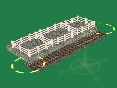
An interactive cattle dock of 3 pens for the S&C.
The dock may be set up in Surveyor for loading or unloading.
For loading, set the 3 load queues' process rates and initial counts to non-zero and those of the unload queues to zero.
For unloading, set the 3 unload queues' process rates non-zero and initial counts to zero. Set all parameters of the load queues to zero.
To assist with correct AI servicing, a speed limit of <10mph is advisable through the dock area.
For the dorrect setup and use of this asset in conjunction with AI LOAD and UNLOAD commands please read the document
'readme_cattle docks' supplied in the asset folder. Note the requirement to terminate sidings with a buffer stop
and an invisible signal, such as <kuid2:45324:24010:1>, immediately in front of it.
When shunting a cattle dock yourself in DCC or CAB mode, your intention to load or unload is inferred.
Relative sizes of dock input and output queues are used to make the inference.
Before driving a consist into the dock for loading or unloading you must enable the dock.
CTRL + RHclick on the dock and LHclick on VIEW DETAILS, then toggle the 'Passive load/unload' control to 'enabled'.
Reset the control to 'disabled' after loading is completed.
With the control left at 'disabled' you may drive on the siding without causing unwanted attempts to load or unload.
| kuid |
author |
kind |
name |
build |
date |
size |
| <kuid:14538:100207> |
#14538 |
map |
WIP Slough to Maidenhead with Portals Power station added |
4.5 |
10.09.2025 0:59:54 |
2.7 MB |
| <kuid:14538:100566> |
#14538 |
map |
A two board MODEL RAILWAY layout in TS12 upload |
3.7 |
28.08.2025 13:25:44 |
391.5 kB |
| <kuid:30024:100346> |
#30024 |
map |
Model Trainz - Bagenalstown |
4.8 |
1.09.2025 15:06:08 |
244.2 kB |
| <kuid:55962:1008> |
#55962 |
map |
Cow Green and Dufton |
2.8 |
10.09.2025 0:24:09 |
139.6 kB |
| <kuid:55962:1036> |
#55962 |
map |
Cow Green and Dufton +portal |
2.8 |
10.09.2025 3:06:23 |
141.1 kB |
| <kuid:78778:100059> |
#78778 |
map |
Asburton |
3.6 |
31.08.2025 23:23:16 |
225.6 kB |
| <kuid:126643:100520> |
#126643 |
map |
IOW Ryde-Ventnor V1 |
3.7 |
21.09.2025 11:03:06 |
2.6 MB |
| <kuid:126643:100545> |
#126643 |
map |
IOW Ryde, Ventnor, Cowes V1 |
3.7 |
21.09.2025 10:50:38 |
4.7 MB |
| <kuid2:126643:100545:1> |
#126643 |
map |
IOW Ryde, Ventnor, Cowes V1 |
3.7 |
21.09.2025 10:51:09 |
4.7 MB |
| <kuid:136114:100049> |
#136114 |
map |
BR (WR) Branch line to Thornbury |
3.8 |
3.09.2025 6:48:35 |
1.4 MB |
| <kuid:186943:103050> |
#186943 |
map |
Dearnby & District v2.0 Revised for build 111951 |
4.8 |
27.09.2025 16:00:49 |
9.1 MB |
| <kuid2:186943:103050:1> |
#186943 |
map |
Dearnby & District v2.0 Revised for build 111951 |
4.8 |
12.09.2025 3:38:38 |
9.1 MB |
| <kuid:234086:100611> |
#234086 |
map |
Ashburton to Windrush Railway (rel) |
3.4 |
1.09.2025 23:39:05 |
1.7 MB |
| <kuid:234086:100617> |
#234086 |
map |
Ashburton to Windrush Railway V2 |
3.4 |
1.09.2025 13:30:49 |
1.7 MB |
| <kuid2:234086:101667:1> |
#234086 |
map |
Much Murkle Redux TS12 |
3.5 |
6.10.2025 0:18:15 |
679.3 kB |
| <kuid:265816:106140> |
#265816 |
map |
Plymouth East & West. Tane |
4.5 |
10.10.2025 17:29:06 |
41.8 MB |
| <kuid:294402:100045> |
#294402 |
map |
Dearnby & District 1970's TRS2022 v3.7 (chuen) |
5.1 |
11.09.2025 22:32:44 |
9.2 MB |
| <kuid2:294402:100058:2> |
#294402 |
map |
Dearnby & District 1970's TRS2022 v4.0 (chuen) |
5.1 |
11.09.2025 22:40:58 |
9.2 MB |
| <kuid:304444:100776> |
#304444 |
map |
DEARNBY: 1960's UK Mainline and 2ft Narrow Gauge v1 |
4.3 |
12.09.2025 2:52:44 |
533.1 kB |
| <kuid:304444:100846> |
#304444 |
map |
DEARNBY: WESTERN REGION: UK 1950's and 2ft Narrow Gauge v1 |
4.3 |
11.09.2025 17:59:01 |
541.6 kB |
| <kuid:304444:100957> |
#304444 |
map |
Mold and Denbigh branchline, North Wales, UK: 1950s-1960s TANE |
4.5 |
5.10.2025 2:12:45 |
7.6 MB |
| <kuid:304444:101096> |
#304444 |
map |
Mold and Denbigh branchline V2 , North Wales, UK: 1950s-1960s TANE |
4.5 |
1.10.2025 5:55:11 |
7.7 MB |
| <kuid:304444:101412> |
#304444 |
map |
Dearnby & District : UK 1950's - 1960's Mainline, Branchline & Narrow Gauge v2.0 |
4.5 |
12.09.2025 3:37:51 |
9.4 MB |
| <kuid:304444:101902> |
#304444 |
map |
Dearnby & District : UK 1950's - 1960's Mainline, Branchline & Narrow Gauge v1 |
4.5 |
11.09.2025 0:10:27 |
7.8 MB |
| <kuid:304444:106213> |
#304444 |
map |
DEARNBY IN MIDWINTER: 1960's UK Mainline & 2ft Narrow Gauge v1.0 |
4.5 |
12.09.2025 0:54:14 |
931.4 kB |
| <kuid:304444:106439> |
#304444 |
map |
DEARNBY IN MIDWINTER: 1960's UK Mainline & 2ft Narrow Gauge v2.0 |
4.5 |
12.09.2025 3:44:19 |
906.3 kB |
| <kuid:304444:115627> |
#304444 |
map |
Dearnbyshire: UK Mainline, Branchline & Narrow Gauge 1950s - 1960s v1 |
5.2 |
12.09.2025 3:55:46 |
38.2 MB |
| <kuid:304444:117612> |
#304444 |
map |
Dearnbyshire v2: UK Mainline, Branchline & Narrow Gauge 1950s - 1960s |
5.4 |
12.09.2025 3:45:59 |
39.6 MB |
| <kuid:318427:1043> |
#318427 |
map |
Harrishire |
2.8 |
16.09.2025 16:12:39 |
8.9 MB |
| <kuid:351596:100007> |
#351596 |
map |
GCR V12 |
4.5 |
16.09.2025 11:02:33 |
23.6 MB |
| <kuid:351596:100012> |
#351596 |
map |
GCR V11 |
4.3 |
16.09.2025 11:00:39 |
14.5 MB |
| <kuid:351596:100028> |
#351596 |
map |
GCR V10 |
4.3 |
16.09.2025 11:28:56 |
13.8 MB |
| <kuid:351596:100245> |
#351596 |
map |
GCR |
3.6 |
20.09.2025 6:34:50 |
3.6 MB |
| <kuid:351596:100265> |
#351596 |
map |
GCR V13 |
4.5 |
16.09.2025 16:25:58 |
25.1 MB |
| <kuid2:351596:100279:8> |
#351596 |
map |
GCR V15 |
4.9 |
16.09.2025 11:05:14 |
34.4 MB |
| <kuid2:351596:100414:2> |
#351596 |
map |
GCR V16 |
5.1 |
20.09.2025 4:10:58 |
35.5 MB |
| <kuid2:351596:100904:1> |
#351596 |
map |
GCR22 V3 |
5.2 |
20.09.2025 13:02:49 |
37.2 MB |
| <kuid:351596:100995> |
#351596 |
map |
GCR V14 |
4.5 |
16.09.2025 11:06:25 |
26.8 MB |
| <kuid:351596:100998> |
#351596 |
map |
GCR Version 2 |
3.6 |
20.09.2025 1:06:34 |
4.2 MB |
| <kuid2:351596:101128:1> |
#351596 |
map |
GCR22 V1 |
5.1 |
16.09.2025 10:54:58 |
35.5 MB |
| <kuid2:351596:101166:1> |
#351596 |
map |
GCR22 V2 |
5.2 |
16.09.2025 13:01:53 |
36.3 MB |
| <kuid:351596:101176> |
#351596 |
map |
GCR V3 |
3.7 |
2.08.2020 9:46:15 |
5.9 MB |
| <kuid2:351596:101570:1> |
#351596 |
map |
GCR22 V4 |
5.4 |
27.08.2024 19:06:10 |
70.1 MB |
| <kuid:351596:101935> |
#351596 |
map |
GCR V4 |
3.7 |
20.09.2025 3:38:26 |
7.2 MB |
| <kuid:351596:102778> |
#351596 |
map |
GCR V5 |
3.7 |
20.09.2025 2:41:05 |
8.6 MB |
| <kuid2:351596:103013:1> |
#351596 |
map |
GCR22 V5 |
5.6 |
6.05.2025 14:13:29 |
72.8 MB |
| <kuid:351596:103906> |
#351596 |
map |
GCR V5 - revised 19Oct14 |
3.7 |
20.09.2025 13:18:51 |
8.7 MB |
| <kuid:351596:104116> |
#351596 |
map |
GCR V6 |
3.7 |
16.09.2025 14:32:41 |
10.5 MB |
| <kuid:355933:100130> |
#355933 |
map |
Ipswitch to Stowmarket |
3.3 |
21.09.2025 18:16:46 |
121.2 kB |
| <kuid2:370074:100038:2> |
#370074 |
map |
BR(WR) V3 Suburban Route & Branch Line. |
3.7 |
5.09.2025 10:14:01 |
6.3 MB |
| <kuid:370074:100129> |
#370074 |
map |
BR (WR) Branch line to Thornbury |
3.7 |
4.09.2025 1:11:31 |
1.4 MB |
| <kuid:406356:100991> |
#406356 |
map |
BR WR Glamorgan Isles New |
3.7 |
5.09.2025 10:34:08 |
1.0 MB |
| <kuid:497137:100118> |
#497137 |
map |
Dearnby & Region V3.0: UK Western Region 1950s & 60s |
5 |
12.09.2025 1:09:35 |
30.9 MB |
| <kuid:497137:102088> |
#497137 |
map |
Dearnby & District v2.0 Revised (DLS) |
4.5 |
11.09.2025 22:27:03 |
9.2 MB |
| <kuid:497137:102233> |
#497137 |
map |
Dearnby & District Revised v2.2 (bus+steel) |
4.5 |
12.09.2025 2:54:21 |
9.7 MB |
| <kuid:514207:100005> |
#514207 |
map |
Chillingbourne - Extended TANE |
4.3 |
6.09.2025 3:38:54 |
277.3 kB |
| <kuid:514207:100012> |
#514207 |
map |
Chillingbourne |
3.7 |
6.09.2025 2:17:49 |
177.4 kB |
| <kuid:514207:100016> |
#514207 |
map |
Chillingbourne - Extended TANE |
4.3 |
6.09.2025 4:38:47 |
426.0 kB |
| <kuid:514207:100033> |
#514207 |
map |
Chillingbourne - Extended |
3.7 |
6.09.2025 6:00:31 |
277.4 kB |
| <kuid2:532993:100044:1> |
#532993 |
map |
Lambourn Valley Railway V4 |
4.5 |
25.09.2025 19:29:02 |
5.7 MB |
| <kuid:555326:100118> |
#555326 |
map |
The Northampton Extension 1.1 |
4.5 |
5.10.2025 12:28:13 |
366.7 kB |
| <kuid:758719:101251> |
#758719 |
map |
F&WVJR - Ellesville Junction - Bromsmouth (With Westbridge line) V1.0 2 |
5.6 |
15.09.2025 6:58:43 |
18.0 MB |
| <kuid:964170:100023> |
#964170 |
map |
Ethan Heritage Railway |
4.7 |
13.09.2025 8:09:54 |
271.4 kB |
| <kuid:1128457:100043> |
#1128457 |
map |
Mold and Denbigh branchline V2 [with ttte] |
5.5 |
30.09.2025 18:55:00 |
7.8 MB |
 Тип: Индустрия