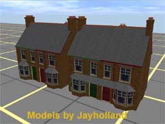
High accuracy and detail model of a pair of typical Victorian semi-detached houses. May be 'painted' the colour of your choice by changing the baseleft.tga and baseright.tga colour files and the doorsleft.tga and doorsright.tga
| kuid |
author |
kind |
name |
build |
date |
size |
| <kuid:149790:100246> |
#149790 |
map |
Badger Tanglefoot - LMS |
4.5 |
31.08.2025 23:32:58 |
14.2 MB |
| <kuid2:149790:100246:1> |
#149790 |
map |
Badger Tanglefoot - LMS |
4.5 |
31.08.2025 23:33:11 |
13.5 MB |
| <kuid:278898:100533> |
#278898 |
map |
0004 2018 APRIL 15TH |
4.5 |
26.08.2025 2:51:32 |
26.9 MB |
| <kuid:304444:100957> |
#304444 |
map |
Mold and Denbigh branchline, North Wales, UK: 1950s-1960s TANE |
4.5 |
5.10.2025 2:12:45 |
7.6 MB |
| <kuid:304444:101096> |
#304444 |
map |
Mold and Denbigh branchline V2 , North Wales, UK: 1950s-1960s TANE |
4.5 |
1.10.2025 5:55:11 |
7.7 MB |
| <kuid:304444:115627> |
#304444 |
map |
Dearnbyshire: UK Mainline, Branchline & Narrow Gauge 1950s - 1960s v1 |
5.2 |
12.09.2025 3:55:46 |
38.2 MB |
| <kuid:304444:117612> |
#304444 |
map |
Dearnbyshire v2: UK Mainline, Branchline & Narrow Gauge 1950s - 1960s |
5.4 |
12.09.2025 3:45:59 |
39.6 MB |
| <kuid:350695:100010> |
#350695 |
map |
East Lynn TANE |
4.5 |
13.09.2025 10:11:19 |
330.9 kB |
| <kuid:350695:100200> |
#350695 |
map |
East Lynn |
3.3 |
12.09.2025 23:16:54 |
209.2 kB |
| <kuid:350695:100216> |
#350695 |
map |
East Lynn v2 |
3.3 |
13.09.2025 1:25:45 |
213.2 kB |
| <kuid:350695:100256> |
#350695 |
map |
East Lynn vPG |
3.3 |
13.09.2025 10:45:23 |
208.7 kB |
| <kuid:351596:100001> |
#351596 |
map |
GCR V8 |
4.2 |
16.09.2025 12:11:02 |
12.1 MB |
| <kuid:351596:100007> |
#351596 |
map |
GCR V12 |
4.5 |
16.09.2025 11:02:33 |
23.6 MB |
| <kuid:351596:100012> |
#351596 |
map |
GCR V11 |
4.3 |
16.09.2025 11:00:39 |
14.5 MB |
| <kuid:351596:100015> |
#351596 |
map |
GCR V9 |
4.2 |
16.09.2025 11:25:02 |
12.6 MB |
| <kuid:351596:100021> |
#351596 |
map |
GCR V7a |
4.2 |
16.09.2025 11:15:44 |
11.6 MB |
| <kuid:351596:100028> |
#351596 |
map |
GCR V10 |
4.3 |
16.09.2025 11:28:56 |
13.8 MB |
| <kuid:351596:100265> |
#351596 |
map |
GCR V13 |
4.5 |
16.09.2025 16:25:58 |
25.1 MB |
| <kuid2:351596:100279:8> |
#351596 |
map |
GCR V15 |
4.9 |
16.09.2025 11:05:14 |
34.4 MB |
| <kuid2:351596:100414:2> |
#351596 |
map |
GCR V16 |
5.1 |
20.09.2025 4:10:58 |
35.5 MB |
| <kuid2:351596:100904:1> |
#351596 |
map |
GCR22 V3 |
5.2 |
20.09.2025 13:02:49 |
37.2 MB |
| <kuid:351596:100995> |
#351596 |
map |
GCR V14 |
4.5 |
16.09.2025 11:06:25 |
26.8 MB |
| <kuid2:351596:101128:1> |
#351596 |
map |
GCR22 V1 |
5.1 |
16.09.2025 10:54:58 |
35.5 MB |
| <kuid2:351596:101166:1> |
#351596 |
map |
GCR22 V2 |
5.2 |
16.09.2025 13:01:53 |
36.3 MB |
| <kuid:351596:101176> |
#351596 |
map |
GCR V3 |
3.7 |
2.08.2020 9:46:15 |
5.9 MB |
| <kuid2:351596:101570:1> |
#351596 |
map |
GCR22 V4 |
5.4 |
27.08.2024 19:06:10 |
70.1 MB |
| <kuid:351596:101935> |
#351596 |
map |
GCR V4 |
3.7 |
20.09.2025 3:38:26 |
7.2 MB |
| <kuid:351596:102778> |
#351596 |
map |
GCR V5 |
3.7 |
20.09.2025 2:41:05 |
8.6 MB |
| <kuid2:351596:103013:1> |
#351596 |
map |
GCR22 V5 |
5.6 |
6.05.2025 14:13:29 |
72.8 MB |
| <kuid:351596:103906> |
#351596 |
map |
GCR V5 - revised 19Oct14 |
3.7 |
20.09.2025 13:18:51 |
8.7 MB |
| <kuid:351596:104116> |
#351596 |
map |
GCR V6 |
3.7 |
16.09.2025 14:32:41 |
10.5 MB |
| <kuid:406356:100025> |
#406356 |
map |
LMS Loch Malloban |
3.7 |
26.09.2025 8:32:23 |
222.7 kB |
| <kuid:497137:100118> |
#497137 |
map |
Dearnby & Region V3.0: UK Western Region 1950s & 60s |
5 |
12.09.2025 1:09:35 |
30.9 MB |
| <kuid2:515942:100004:1> |
#515942 |
map |
1930s Cornish Mainline and Branches - Truro to Penzance |
4.3 |
27.08.2025 6:52:15 |
50.9 MB |
| <kuid:515942:100072> |
#515942 |
map |
TANE, 1930s Cornish Mainline - Truro to Penzance, Phase 1 Redruth |
4.2 |
16.09.2025 12:30:41 |
5.7 MB |
| <kuid:515942:100218> |
#515942 |
map |
1930s English Branchline - The Maritime Line (Truro to Falmouth) |
3.7 |
27.08.2025 16:29:27 |
10.2 MB |
| <kuid:515942:100271> |
#515942 |
map |
Revised 1930s English Branchline - The Maritime Line (Truro to Falmouth) |
3.7 |
15.09.2025 22:13:14 |
10.2 MB |
| <kuid:515942:100313> |
#515942 |
map |
1930s Cornish Mainline - Truro to Penzance, Phase 1 Redruth |
3.7 |
27.08.2025 16:43:42 |
5.9 MB |
| <kuid:515942:100334> |
#515942 |
map |
1930s Cornish Mainline - Truro to Penzance, Camborne Sector |
3.7 |
28.08.2025 13:36:24 |
8.7 MB |
| <kuid:515942:100360> |
#515942 |
map |
1930s Cornish Mega Package |
3.7 |
28.08.2025 13:36:53 |
16.6 MB |
| <kuid:844571:105469> |
#844571 |
map |
Milwaukee Road Iowa/Illinois Subdivision |
4.5 |
5.10.2025 4:51:52 |
1.3 MB |
| <kuid:844571:106069> |
#844571 |
map |
Rock Island/ Iowa Interstate Iowa/Illinois |
4.5 |
29.10.2025 9:09:07 |
1.2 MB |
| <kuid:850934:101722> |
#850934 |
map |
1930 Cornish Full - Mini |
4.5 |
28.08.2025 13:36:02 |
70.0 MB |
| <kuid:879914:101170> |
#879914 |
map |
1930s Cornish Mainline and Branches - Truro to Penzance with out trains |
4.5 |
27.08.2025 17:20:59 |
70.2 MB |
| <kuid:919773:100350> |
#919773 |
map |
BRR2 |
4.6 |
5.09.2025 12:03:21 |
118.0 MB |
| <kuid:940583:100325> |
#940583 |
map |
Milwaukee Road Iowa/Illinois Subdivision 8-5-21 5:21 PM |
4.8 |
1.10.2025 5:11:59 |
1.4 MB |
| <kuid:952290:100056> |
#952290 |
map |
my route island of sodor (done)( 1.0 |
4.5 |
5.10.2025 21:21:46 |
25.9 MB |
| <kuid:1128457:100043> |
#1128457 |
map |
Mold and Denbigh branchline V2 [with ttte] |
5.5 |
30.09.2025 18:55:00 |
7.8 MB |
 Тип: scenery