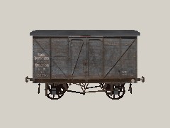
Revised asset for the Ashburton-Windrush Railway route.
This is a revision of John Whelan's GWR flour van scenery whose licence and copyright are retained in full for this item. My thanks to the original author for allowing me to revise his excellent work!
Photo texture from Chris Whiting who retains copyright. Couplings curtsey of Paul Hobb's Blender library.
You'll find this one under track. It has three levels of LOD, and is a pure scenery object so don't place it on a track you expect to run a train along.
| kuid |
author |
kind |
name |
build |
date |
size |
| <kuid:149790:100436> |
#149790 |
profile |
GWR - Tristyn |
4.6 |
20.09.2025 1:43:23 |
201.7 kB |
| <kuid:186943:103050> |
#186943 |
map |
Dearnby & District v2.0 Revised for build 111951 |
4.8 |
27.09.2025 16:00:49 |
9.1 MB |
| <kuid2:186943:103050:1> |
#186943 |
map |
Dearnby & District v2.0 Revised for build 111951 |
4.8 |
12.09.2025 3:38:38 |
9.1 MB |
| <kuid:191554:100199> |
#191554 |
map |
EAST GRINSTEAD to BRIGHTON 2 |
3.7 |
12.09.2025 23:11:31 |
2.5 MB |
| <kuid:191554:100303> |
#191554 |
map |
EAST GRINSTEAD to BRIGHTON 3 |
3.7 |
13.09.2025 4:02:30 |
2.6 MB |
| <kuid:234086:100611> |
#234086 |
map |
Ashburton to Windrush Railway (rel) |
3.4 |
1.09.2025 23:39:05 |
1.7 MB |
| <kuid:234086:100617> |
#234086 |
map |
Ashburton to Windrush Railway V2 |
3.4 |
1.09.2025 13:30:49 |
1.7 MB |
| <kuid:265816:100167> |
#265816 |
map |
PLYMOUTH LAUNCESTON OKEHAMPTON |
3.7 |
9.10.2025 9:45:22 |
9.0 MB |
| <kuid:265816:103331> |
#265816 |
map |
Cambrian & LNWR Railways |
4.5 |
6.09.2025 1:15:22 |
32.2 MB |
| <kuid:265816:106140> |
#265816 |
map |
Plymouth East & West. Tane |
4.5 |
10.10.2025 17:29:06 |
41.8 MB |
| <kuid:278898:103266> |
#278898 |
profile |
5021 FEB 26th - Default |
4.6 |
27.08.2025 9:53:42 |
10.6 MB |
| <kuid:278898:103278> |
#278898 |
profile |
5022 april 6th - Default |
4.6 |
27.08.2025 10:07:38 |
10.6 MB |
| <kuid:304444:100957> |
#304444 |
map |
Mold and Denbigh branchline, North Wales, UK: 1950s-1960s TANE |
4.5 |
5.10.2025 2:12:45 |
7.6 MB |
| <kuid:304444:101096> |
#304444 |
map |
Mold and Denbigh branchline V2 , North Wales, UK: 1950s-1960s TANE |
4.5 |
1.10.2025 5:55:11 |
7.7 MB |
| <kuid:304444:117612> |
#304444 |
map |
Dearnbyshire v2: UK Mainline, Branchline & Narrow Gauge 1950s - 1960s |
5.4 |
12.09.2025 3:45:59 |
39.6 MB |
| <kuid:370074:100038> |
#370074 |
map |
BR(WR) Branch Line (For TS12) |
3.6 |
5.09.2025 10:13:21 |
3.8 MB |
| <kuid2:370074:100038:2> |
#370074 |
map |
BR(WR) V3 Suburban Route & Branch Line. |
3.7 |
5.09.2025 10:14:01 |
6.3 MB |
| <kuid:497137:102088> |
#497137 |
map |
Dearnby & District v2.0 Revised (DLS) |
4.5 |
11.09.2025 22:27:03 |
9.2 MB |
| <kuid:497137:102233> |
#497137 |
map |
Dearnby & District Revised v2.2 (bus+steel) |
4.5 |
12.09.2025 2:54:21 |
9.7 MB |
| <kuid:1128457:100043> |
#1128457 |
map |
Mold and Denbigh branchline V2 [with ttte] |
5.5 |
30.09.2025 18:55:00 |
7.8 MB |
 Тип: scenery